
By Sherry Bunting, Farmshine, June 28, 2024
EAST EARL, Pa. – Pray for rain. Pray it stops. The contrast could not be starker.
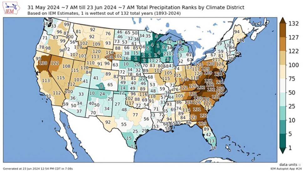
The Mid-Atlantic and Ohio Valley is in the throes of one of the driest growing seasons on record. Meanwhile, the season was already one of the wettest on record throughout the Upper Midwest and Northern Plains before the 8 to 15 inches June 21-23 led to historic catastrophic flooding in northwest Iowa, southeast South Dakota, and southern Minnesota.
The June 24th USDA Crop Progress Report showed a 3 point decline in good-to-excellent corn condition, nationally, falling to 69%. But, sticking in the market’s crawl is the earlier-projected corn crop estimates and the mere 50% good-to-excellent corn crop condition reported for this same week a year ago.
Soybean condition fell 5 points to 67% this week. Again, this beats the 51% good-to-excellent condition reported this same week a year ago.
The impacts on damaged crops and potentially lower yields from floods have yet to be assessed in a region that had already delayed planting, drained and replanted.
Grain markets are shrugging off the weather woes, appearing to be focused primarily on the demand side of the equation looking toward the upcoming end-of-month Grain Stocks report.
Some analysts are expecting an overall bearish mode to hold through at least month-end or longer, despite news emerging of untold acres of corn and soybeans under water along rivers and lakes in Iowa, Minnesota and South Dakota.
Governors of the three states declared statewide emergencies and named scores of counties under disaster declarations. President Biden has announced a federal disaster declaration in Iowa, opening up federal funding there. Other areas may not be far behind.
Lakes and rivers in the region reached levels reportedly higher than in 1993. Towns are under water, nobody in and nobody out, with boat rescues off rooftops and rescues via National Guard helicopters.
As the Big Sioux and Des Moines Rivers reached levels as much as 7 feet above previous records, a 100-year-old Minnesota dam failed, and two railway bridges collapsed that transported ag commodities.
Grain markets did not care. Early this week (June 24-25), “the markets tanked,” said Eric Relph with Commstock Investments in a Marin Bohling interview on the Commstock Channel Tuesday morning (June 25). No market strength emerged yet by Friday. Instead, more red.
“We are still fighting the mentality that rain makes grain,” said Relph.
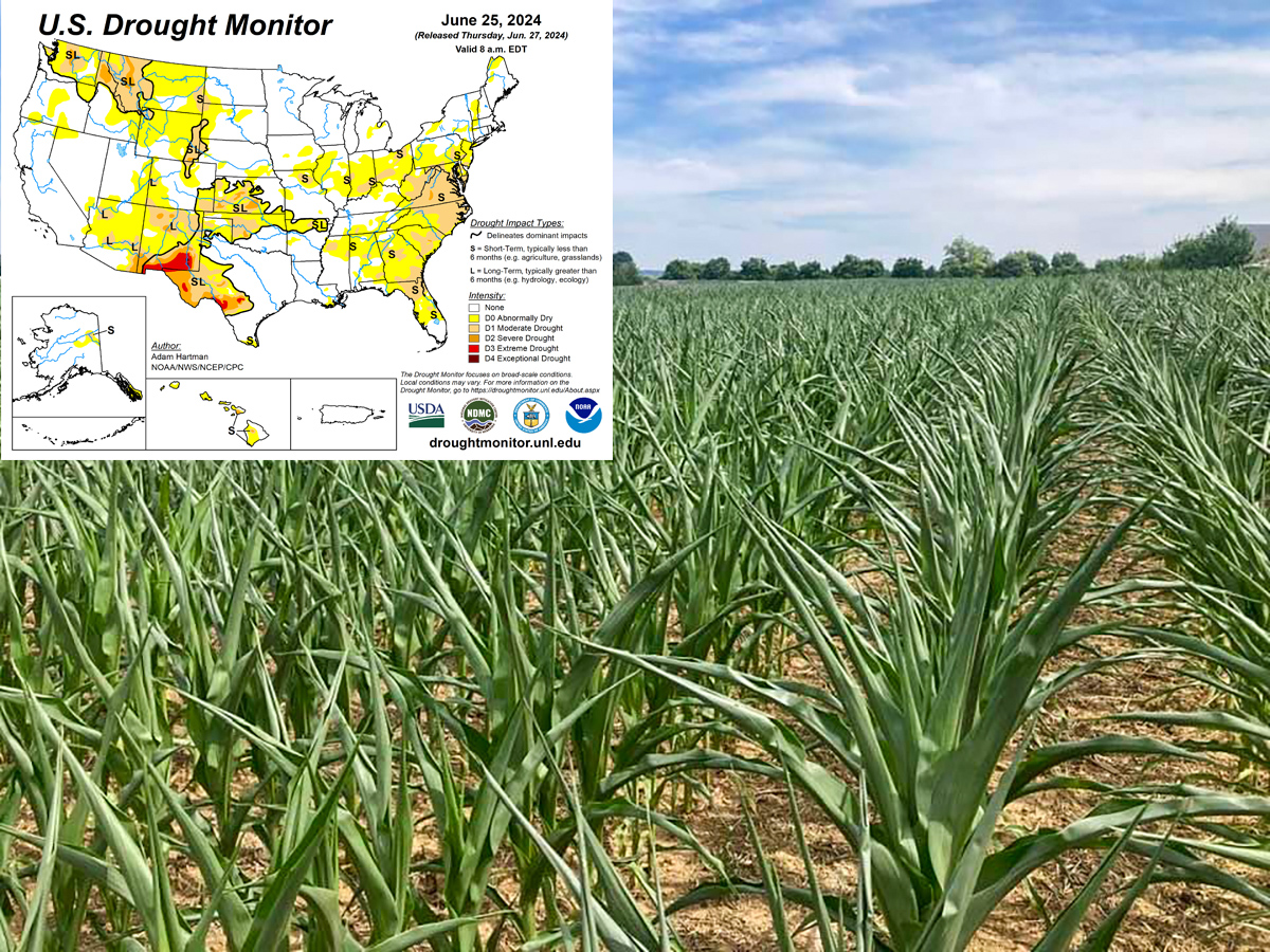
“The concern grows when we have other big chunks of other major growing regions very dry in Illinois, Indiana, and Ohio, having had no rain in three weeks, with cracks in the ground, and plants curling and temperatures up at 75 overnight.”
Analysts are looking back at reactions to the summer flooding of 1993. But as farm broadcaster Max Armstrong observed in a tweet on X (formerly Twitter) Wednesday morning (June 26): “The South America behemoth makes tragic, sickening U.S. flooding far less consequential to the world than it did three decades ago.”
Farmers have taken to social media showing aerial footage of flooded fields, updating ever-increasing rainfall totals while walking the sprayer tracks that have become rivers in a swamp, along with images of busted corn bins and piles of flood-soaked corn in rural towns of northwest Iowa, like Spencer and Rock Valley, all within the targeted dairy growth area of the I-29 Corridor.
The problem, according to Relph, is the region had full moisture profiles coming into the Spring, then more rain constantly through April and May. This was before this 8 to 15 inches of rain that inundated the region.

Relph lives and works there. He described the geographic impact as substantial:
“At the western front of this area that is receiving this kind of rain, we move straight east through Iowa, with as much as 40% of Iowa affected, and it’s up into South Dakota and even North Dakota to a degree, and into central, the southern quarter of Minnesota, over into central Wisconsin and down along the Mississippi, missing Illinois, but including eastern Iowa,” he reported.
Iowa Ag Secretary Mike Naig said state officials won’t have a full sense of the crop damage or number of livestock lost in the region until the flood waters recede.
“This was already a wet part of the state, where there were some challenges around planting and replanting. They’ve just been inundated with rain throughout the spring. We’re hearing about damaged and destroyed equipment. There are livestock facilities that folks are having trouble getting feed to because of washed-out roads, and there are power outages and water outages. These are just some of the things that are really challenging,” Sec. Naig reported.
Farmers are resilient, and they are helping each other get through the most damaging elements and waiting to see how many fields will bounce back, if not under water more than two or three days. Some analysts say growers are not likely to pour management dollars into fields, depending on what the yield losses are predicted to be. It’s virtually too late to replant, even if conditions allow.
As one set of problems affects one region and another set of problems confronts another, Relph said: “It’s a tale of two halves. Without a shift in the weather pattern, it will be detrimental.”
Other analysts interviewed on Rural Radio Wednesday morning point to U.S. and European weather models that show more rain to come in the flooded region, but also going all the way East, keeping the bears in charge of the grain markets, with corn June 25 trading under February lows.
Meanwhile, the concerns now shift as the already flooding rivers flow into the Missouri and Mississippi.
In addition, sources indicate transportation has been affected by I-29 closures in spots from Sioux City, Iowa to Sioux Falls, South Dakota, affecting movement of supplies in and milk out. Trips take four times longer via back roads, and even there, washed out roads are encountered leaving some farms in a tough spot, while suppliers in affected nearby towns face difficulty getting out.
Some roads and portions of I-29 were reopening or partially reopening late June 25 into June 26, but new areas are bracing for the Missouri and Mississippi that are forecast to crest at major levels June 26 and into the first week of July.
Meanwhile, the NOAA Weather Prediction Center map shows rain and strong storms continuing in the Upper Midwest while overspreading the Ohio Valley and into the Mid-Atlantic by June 28.
As for the Midwest, The Weather Channel warns of severe flood risk returns as meteorologists are watching a new system ejecting from the Rockieswith the potential to bring a continued risk of flooding and severe weather in already impacted areas into July.
-30-
